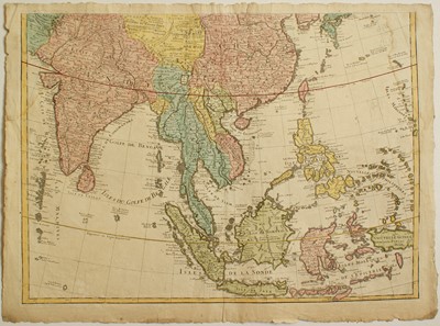
Carte des Indes et de la Chine

Philippe BUACHE
( 1700 – 1773 )
“Carte des Indes et de la Chine”
Original etching dated lower right 1745 beside the signature of Buache that is named “Gendre de l'Auteur” (son in law of the autor), it is the reworked map of Guillaume de L'Isle published in 1720 but the lower part only.
Very nice example printed on laid paper showing a watermark “Fin Auvergne 1742” relating to french paper production of the XVIIth century, with untouched margins around the platemark, the usual central binding fold, small tears, folds and waterstaining, otherwise in good general condition.
Embellished with a bright, accurate, watercoloring.
The map shows Southeast Asia from India to the Philippines including the Maldives, Malaysia, Thailand, Sumatra, Java, Borneo and the Moluques.
References:
Moreland – Bannister “Antique Maps ...” Oxford 1989 pag.134.
Size in mm: 495ca x 660
Price: € 350,00
